
This Region includes Bennington & Windham Counties!
| Bennington County |
click
on small photos to see larger photo!
|
 |
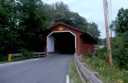
ARLINGTON, BRIDGE AT THE GREEN 45-02-01, Town Lattice Truss, built in 1852, builder unknown, is located on Covered Bridge Road. The GPS location is N43 06.259 W73 13.219. |
 |
BURT HENRY BRIDGE 45-02-02#2, Town Lattice Truss, built c.1840, original builder unknown, rebuilt in 1989 by Blow & Cote, Inc. It is located on River Road. The GPS location is N42 54.749 W73 15.277. |
 |
PAPER MILL, VILLAGE BRIDGE 45-02-03#2, Town Lattice Truss, built in 1889, demolished in December 1999, & re-built IN 2000. It is located on bypassed section of Murphy Road. The GPS location is N42 54.764 W73 14.012. |
 |
SILK ROAD, LOCUST GROVE, ROBISON BRIDGE 45-02-04, Town Lattice Truss, built c.1840, builder probably Benjamin Sears. It is located on Silk Road. The GPS location is N42 54.565 W73 13.526. |
 |
CHISELVILLE BRIDGE 45-02-05, Town Lattice W/Cement Deck added, built in 1870, is located on the NE edge of East Arlington, on Maple Street. The GPS location is N43 04.329 W73 07.990. |
 |
KREFFER BRIDGE, 45-02-A, Stringer, built in 1977, is located south of Sandgate on the ease side of Sandgate Road. The GPS location is N43 08.338 W73 12.219. |
| Windham County | |
 |
The GPS location is N42 51.011 W72 35.108. |
 |
WEST DUMMERSTON BRIDGE 45-13-02#2, Town Lattice Truss, built in 1872 & restored in 1998, is located North of West Dummerston on East West Road. The GPS location is N42 56.195 W72 36.768. |
 |
KIDDER HILL BRIDGE 45-13-03, Kingpost Truss, built in 1870 is located in the town of Grafton on Bear Hill Road (dead end road). The GPS location is N43 10.139 W72 36.329. |
 |
GREEN RIVER BRIDGE 45-13-04, Town Lattice Truss, built in 1870, is located in the village of Green River on Jacksonville Stage Road. The GPS location is N42 46.54 W72 40.02. |
 |
The GPS location is N42 56.575 W72 41.203. |
 |
HALL, OSGOOD BRIDGE 45-13-07#2, Town Lattice Truss, built in 1982 to replace a much older covered bridge. It is located on Paradise Hill Road, East of Saxtons River. The GPS location is N43 08.242 W72 29.236. |
 |
WORRAL BRIDGE 45-13-10, Town Lattice Truss, built in 1868 is located in Bartonsville, off VT 103 on Lower Bartonsville Road. The GPS location is N43 12.707 W72 32.132. |
 |
BARTONSVILLE BRIDGE 45-13-11#2, Town Lattice Truss, built in 1870, was located in Bartonsville on Lower Bartonsville Road. It was rebuilt in 2012. The GPS location was N43 13.440 W72 32.217. |
 |
SCOTT BRIDGE 45-13-13, Town Lattice & Kingpost Truss, built in 1870, is located west of Townshend on bypassed section of Back Side Road. Closed to motor vehicles. The GPS location is N43 02.95 W72 41.75. |
 |
VICTORIAN VILLAGE, DEPOT BRIDGE 45-13-23, Kingpost Truss, built in 1967, using wood from the 45-13-12 bridge. It is located at the Vermont Country Store near Rockingham. The GPS location is N43 11.809 W72 30.248. |
 |
HIGH MOWING FARM, TWIN SILOS BRIDGE 45-13-A, Town Lattice Truss, built in 1949 by the Haynes Brothers, is located at Wilmington, on the east side of Stowe Hill Road, on a farm access road. The GPS location is N42 52.98 W72 51.01. |
 |
McWILLIAM, GRAFTON CHEESE FACTORY BRIDGE 45-13-E, Stringer, built in 1967 by S. MacMillan, is located on the east side of Townshend Road. The GPS location is N43 09.978 W72 36.784. |
South Central VT | North Central VT | Northeastern VT | Northwestern VT | HOME
PENNSYLVANIA
|
CALIFORNIA |
CONNECTICUT
| DELAWARE | INDIANA
| MAINE | MARYLAND
MASSACHUSSETTS | NEW
HAMPSHIRE | NEW JERSEY | NEW
YORK | OHIO | RHODE
ISLAND | VERMONT
VIRGINIA | WEST
VIRGINIA | BRIDGING LINKS | HOME