1.
LONG ISLAND
NASSAU & SUFFOLK COUNTIES
SUFFOLK
COUNTY
 |
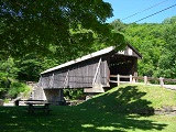
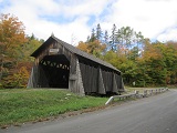
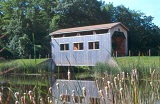
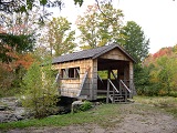
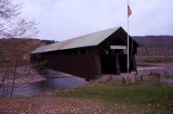
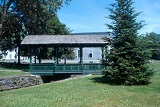
LUDLOW
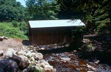
GREENS, NY-52-02, Town Truss, built in 1990 by Jonathan Foster.
It is 50' long. It is located on Long Island, in Bridgehampton,
on Edgewood Ave.
The
GPS location is N40 56.55 W72 17.47.
|
2.
NEW YORK CITY
BROOKLYN, BRONX, MANHATTAN, QUEENS & STATEN ISLAND
No Covered Bridges
3.
LOWER HUDSON VALLEY
DUTCHESS, ORANGE, PUTNAM, ROCKLAND, SULLIVAN, ULSTER & WESTCHESTER
COUNTIES
SULLIVAN
COUNTY
 |
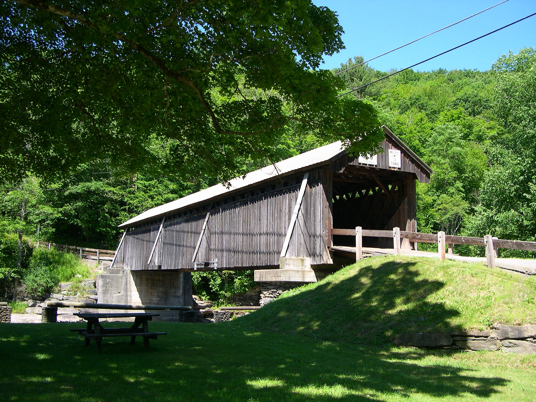
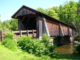
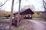
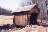
HALLS
MILLS BRIDGE, 32-53-01, Town Lattice Truss, built by David Benton
& John Knight in 1912.It is 119' long & hasn't yet been
added to the National Register. It is located in the town of
Neversink, off Hunter Road. It is in the process of being re-furbished.
The
GPS location is N41 53.42 W074 35.40.
|
 |
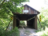
BEAVERKILL
BRIDGE, 32-53-02, Town Lattice Truss, built by John Davidson
in 1865. It is 98' long & is currently on the books for
the National Register. It is located on Campsite Road in Beaverkill
State Campsite, SW of Lewbeach.
The
GPS location is N41 58.893 W74 50.170.
|
 |
LIVINGSTON
MANOR, VAN TRAN FLAT BRIDGE, 32-53-03, Town Lattice Truss, built
by John Davidson in 1860. It is 117' long & is yet to be
added to the National Register. It is located on Covered Bridge
Road, North of Livingston Manor.
The
GPS location is N41 54.87 W74 49.90.
|
 |
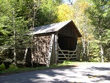
BENDO
BRIDGE, 32-53-04, Town Lattice Truss, built by John Davidson
in 1860 in Livingston Manor, moved to present position in 1913.
It is 48' long & does not qualify for the National Register.
It is located in Covered Bridge Campsite on Conklin Road. Permission
to visit is needed.
The
GPS location is N41 54.40 W74 41.97.
|
 |
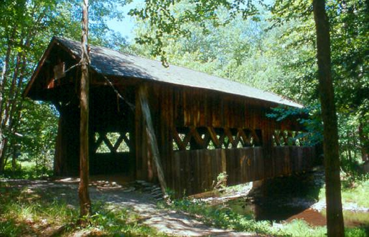
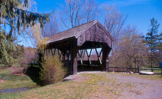
GRAHAMSVILLE
BRIDGE, 32-53-B, Stringer, built in 1976, is located NW of Grahamsville,
on the south side of Rte. 55.
The GPS location is N41 51.273 W74 33.296.
|
ULSTER
COUNTY
 |
PERRINE
BRIDGE, 32-56-01, Burr Arch Truss, built by Benjamin Wood in
1844, restored in 1969. It is 138' long & was added to the
National Register on April 13, 1973. It is located on North
side of bypassed section of NY213, SW of Rifton, near I-87 exit.
The
GPS location is N41 49.508 W74 03.343.
|
 |
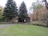
FORGE
BRIDGE, 32-56-02, Kingpost Truss, built by Salem Jerome Moot
in 1906. It is 27' long & is currently in the books for
the National Register. It is the only Kingpost Truss in New
York state & shortest. It is located SE of Arkville, on
Dry Brook Road, along south side, on a private road. Permission
needed to visit bridge. It was damaged by Tropical Storm Irene
and will be repaired.
The
GPS location is N42 04.756 WE74 33.163.
|
 |
TAPPAN,
KITTLE BRIDGE, 32-56-03, built in by Salem Jerome Moot in 1870
as a Kingpost Truss. It is 43' long It was re-built in 1985
as a Stringer truss. It does not qualify for the National Register.
It is located along Dry Brook Road, on private land. It was
slightly damaged by Tropical Storm Irene but can still be driven
on.
The
GPS location is N42 03.946 W74 32.841.
|
 |
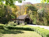
ASHOKAN,
TURNWOOD BRIDGE, 32-56-05, Town Lattice Truss, built by Nelson
Tomkins in 1885, moved to Olivebridge in 1930. It is located
on Beaverkill Road at The Ashokan Center. There is a fee to
walk the grounds.
The
GPS location is N41 55.673 W74 11.755.
|
 |
MILL
BROOK BRIDGE, 32-56-06, Town Lattice Truss, built by Edgar Marks,
Orrin Marks & Wesley Alton in 1902, restored in 1992. It
is 66' long & was added to the National Register on December
17, 1998. It is located South of Margaretville, on Mill Brook
Road. It was damaged by Tropical Storm Irene.
The
GPS location is N42 04.827 W74 38.195.
|
 |
MEYERS
BRIDGE, 32-56-D, Stringer, is located on Dry Brook Road.
The
GPS location is N42 03.51 & W74 32.39.
|
 |
FRIENDSHIP
MANOR BRIDGE, 32-56-E, Stringer, built in 1992, by Fort Miller
Co. & Chesterfield Associates. It is located at the entrance
to Catskill State Park.
The GPS location is N42 07.53 W74 28.27.
|
4.
CAPITAL REGION/NORTHERN CATSKILLS
ALBANY, COLUMBIA, DELAWARE, GREENE, MONTGOMERY, OSTEGO, RENSSELAER,
SCHENECTADY & SCHOHARIE COUNTIES
ALBANY
COUNTY
 |
WALDBILLIG
BRIDGE, 32-01-01, Warren Truss, built by Gerald & Michael
Waldbillig in 1955 is 30' long. It is located NE of Voorheesville,
on private land, off Normanskill Road (CR20). It does not qualify
for the National Register. Please get permission from owner
to visit.
The
GPS location is N42 39.837 W73 53.705.
|
 |
OTTERNESS
WAY BRIDGE, 32-01-c, Stringer, built in 1978, is located behind
the Voorheesville School between a parking lot & the school,
on the south side of rte. 156.
The
GPS location is N42 38.963 W73 56.195.
|
 |
COLONIE
TOWN PARK BRIDGE, 32-01-D, Stringer. It is located 0.7 miles
into Colonie Township Park in Latham.
The
GPS location is N42 48.030 W73 44.603.
|
DELAWARE
COUNTY
 |
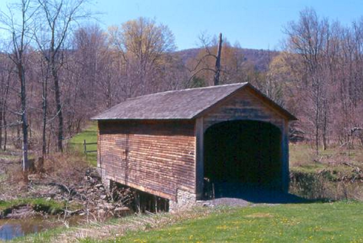
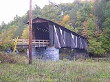
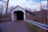
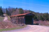
DOWNSVILLE
BRIDGE, 32-13-01, Long with Queenpost Truss, built in 1854 by
Robert Murray. It is 174' long & it was added to the National
Register on April 29, 1999. It is New York State's Longest Operating
Covered Bridge. It is located in Downsville, NY, on Bridge Street.
The
GPS location is N42 04.573 W74 59.443.
|
 |
FITCH'S
BRIDGE, 32-13-02#2, Town Lattice Truss, built by James Frazer
& James Warren in 1870 & moved to present position in
1885. It is 113' long & was added to the National Register
on April 29, 1999. It is located off NY 10, on Fitches Bridge
road, NE of Dehli.
The
GPS location is N42 17.894 W74 52.757.
|

|
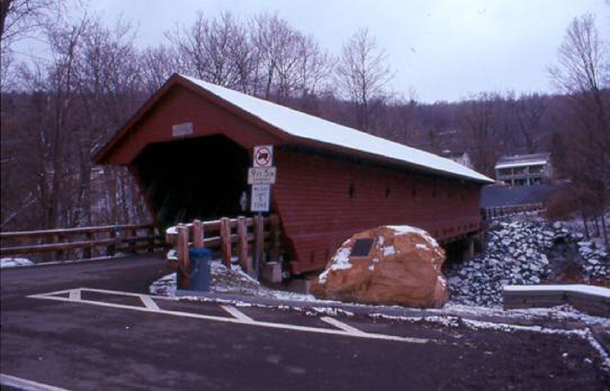
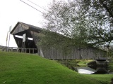
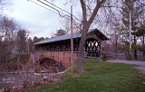
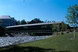
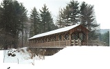
HAMDEN BRIDGE, 32-13-03#2 Long Truss, built by Robert Murray
in 1859.It was added to the National Register on April 29, 1999.
It is 128' long. It is located on Basin Clove Road, 6 miles
SW of Dehli.
The
GPS location is N42 11.739 W74 59.303.
The second photo of the Hamden Bridge was given to me by my
NY covered bridge friend Trish Kane after a recent re-furbishing.
|
 |
TUSCARORA
CLUB, DEMIS BRIDGE, 32-13-05#2, built by William Mead in 1870
as a Kingpost Truss & relocated in 1935 in Dunraven,
NY. It was 38' long & did not qualify for the National Register.
It was destroyed by Hurricane Irene on August 28, 2011. The
bridge was been rebuilt in 2012 by Arnold M. Graton Associates,
Inc. Request permission at Lodge 2.0 miles ahead on left.
The
GPS location is N42 05.22 W074 41.46
|
 |
LOWER
SHAVERTOWN, formerly known as CAMPBELL, 32-13-07, Town Lattice
Truss, built in 1877 by Anson Jenkins & August Neidig in
Shavertown, NY, moved to present position by Carl Campbell in
1954. It was added to the National Register on April 29, 1999.
It is 32' long. It is located on Methol Road, on private land,
WSW of Cooks Falls.
The
GPS location is N41 55.402 W75 00.784.
|
 |
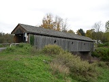
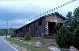
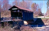
ERPF
BRIDGE, 32-13-08, Town Lattice Truss, built by Seager Fairburn
in 1964, is located SE of Arkville, off Erpf Road, on private
land. It is 31' long & does not qualify for the National
Register. The photo included was given to me by my New York
Covered Bridge Society friend Trish Kane. An appointment
is needed to visit.
The
GPS location is N42 08.646 W74 36.035.
|
 |
FROSCH
BRIDGE 32-13-F, Stringer, built in 1977, across Beaver Run SSE
of Hancock, NY on Covered Bridge Rd. 300’ to the bridge.
The
GPS location is N41 54.03 W75 13.72)
|
 |
CHURCH
STREET STATION 32-13-g, Stringer was built in 1987 across a
creek in Arkville, Delaware County, NY. It is now located in
a parking lot off Church Street.
The
GPS location is (N42 08.886 W74 36.996)
|
OSTEGO
COUNTY
 |
HYDE
HALL BRIDGE, 32-39-01, Burr Arch Truss, built by Cyrenus Clark,
Andrew & Lorenzo Bates in 1825. It is the oldest in the
United States. It is 53' long & was added to the National
Register on December 17, 1998. It is in Glimmerglass State Park,
near East Springfield. It survived the Tropical Storm Irene
but for a branch punctured the siding.
The
GPS location is N42 47.414 W74 51.812.
|
RENSSELAER-WASHINGTON
COUNTY
 |
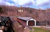
BUSKIRK
BRIDGE, 32-42-02#2 & 32-58-04#2, Howe Truss, built by Peter
O. Osterhauth, Charles Newman, James B. Roberts & Charles
F. Ingalls in 1857. It is 53' long & was added to the National
Register on March 8, 1978. It is 158' long & is located
at Buskirk, on Buskirk West Hoosick Road CR 59. It is shared
with Washington County.
The
GPS location is N42 57.495 W73 25.988.
|
SCHOHARIE
COUNTY
 |
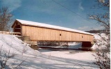
BLENHEIM
BRIDGE, 32-48-01#2, Double-Barreled Long Truss with Arch, (very
rare type), built by Nicholas Montgomery Powers in 1855. It
is 228' long & was added to the National Register on October
15, 1966. It was the longest covered bridge in New York State.
It was destroyed by Hurricane Irene on August 28, 2011. It was
rebuilt in 2018.
The
GPS location was N42 28.305 W74 26.490.
|
 |
SCHOHARIE
BRIDGE, 32-48-B, Stringer. It is located at Schoharie, on
Main Street, at the 1785 Col. Peter Vroman House.
The GPS location is N42 40.77 W74 18.06.
|
5.
EASTERN ADIRONDACKS/LAKE CHAMPLAIN
CLINTON, ESSEX, FRANKLIN, FULTON, HAMILTON, SARATOGA, WARREN &
WASHINGTON COUNTIES
ESSEX
COUNTY
 |
JAY
BRIDGE, 32-16-01, Howe Truss, built by George M. Burt in 1857.
It is located in Jay, on Covered Bridge Lane. It is completely
rebuilt & placed over water.
The
GPS location is N44 22.38 W73 43.50.
|
 |
FORT TICONDEROGA,
KISSING BRIDGE, 32-16-E, Town-like structure, built in 1994
by the Elk Club, is located West of Fort Ticonderoga Historic
site in Bicentennial Park, off NY 22.
The
GPS location is N43 50.96 W73 25.12.
|
FULTON
COUNTY
 |
EAGLE
MILLS BRIDGE, 32-18-01, Town Truss, built by John Gasner in
1967. It is 40' long and does not qualify for the National Register.
It is located East of Broadalbin, off Eagle Mills Road, at Eagle
Mills Cider Company.
The
GPS location is N43 04.80 W74 07.77.
|
 |
MOREHOUSE
BRIDGE, 32-18-c, Stringer, built in 1991 by Douglas Morehouse,
is located along the north side of Route 29, south of Broadalbin,
on private property.
The GPS location is N43 03.23 W74 11.78.
|
SARATOGA
COUNTY
 |
COPELAND
BRIDGE, 32-46-01, Queenpost Truss, built by Arad Copeland in
1879. It is 35' long & was added to the National Register
on August 6, 1998. It is the only historic Queenpost in New
York state. It is located East of Edinburg, along North Shore
Road, on private property.
The
GPS location is N43 13.255 W74 06.015.
|
WASHINGTON
COUNTY
 |
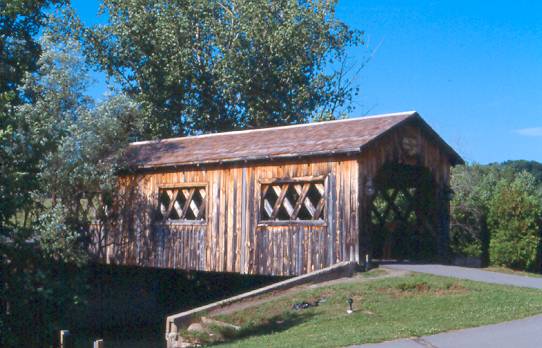
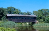
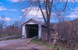
EAGLEVILLE
BRIDGE, 32-58-01, Town Lattice Truss, built by Ephraim W. Clapp
in 1858. It is 100' long & was added to the National Register
on March 8, 1978. It is located on Eagleville Road, off NY 313,
in Eagleville.
The
GPS location is N43 04.993 W73 18.822.
|
 |
SHUSHAN
BRIDGE, 32-58-02, Town Lattice Truss, built by Milton &
James C. Stevens in 1858 & relocated in 1963.It is 161'
long & was added to the National Register on March 8, 1978.
It is located at the intersection of CR 61 & CR64, at Shushan.
The
GPS location is N43 05.477 W73 20.731.
|
 |
REXLEIGH
BRIDGE, 32-58-03#2, Howe Truss, built by Reuben Comins &
George Wadsworth in 1874, restored in 1984. It is 107' long
& was added to the National Register on March 8, 1978. It
is located SSW of Salem, on Rexleigh Road.
The
GPS location is N43 08.088 W73 21.338.
|
 |
SEEDHOUSE/ASGROW
GARDENS, 32-58-a, a 23-foot Stringer footbridge, built in 1890,
is located along Rte 372, in a small park in Cambridge.
The
GPS location is N43 01.673 W73 22.983.
|
 |
SLATE
BRIDGE, 32-58-d, built in 2000,a non-authentic footbridge, was
located behind the Slate Valley Museum in Granville on Rathbun
Avenue. It has been removed.
The
GPS location is N43 24.33 W73 15.75.
|
6.
WESTERN ADIRONDACKS/EASTERN LAKE ONTARIO
HERKIMER, JEFFERSON, LEWIS, ONEIDA & ST.LAWRENCE COUNTIES
HERKIMER
COUNTY
 |
ALVAH
HOPSON, SALISBURY CENTER BRIDGE, 32-22-01, Multiple Kingpost
& Arch Truss, built by Alvah Hopson in 1875. It is 50' long
& was added to the National Register on June 19, 11972.
It is located at Salisbury Center, off NY 29, on Fairview Road.
The
GPS location is N43 08.44 W74 47.27.
|
 |
OLD
FORGE BRIDGE, 32-22-b, Stringer, built in 1987, is located in
Old Forge, on the south side of NY28.
The
GPS location is N43 42.70 W74 58.18.
|
JEFFERSON
COUNTY
 |
FRONTENAC,
NORTH COUNTRY BRIDGE, 32-23-E, Town Lattice Truss, built by
C. Gary Beckstead in 1979. It is 45' long & does not qualify
for the National Register. It is located North of Bellville
at Butterville, on private property, along Butterville Road.
Ask permission to visit!
The
GPS location is N43 50.61 W76 06.20.
|
ONIEDA
COUNTY
 |
ROYDHOUSE
BRIDGE, 32-33-C, built in 1979, is located along Rte. 20 West,
at Bridgewater, on Doe Road.
The
GPS location is N42 53.71 W75 18.00.
|
7.
CENTRAL NEW YORK
BROOME, CAYUGA, CHENANGO, CORTLAND, MADISON, ONONDAGA, OSWEGO, TIOGA
& TOMPKINS COUNTIES
BROOME
COUNTY
 |
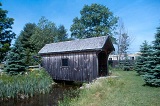
MUNSON
BRIDGE, 32-04-h, Queenpost Truss, built by Robert & Rachel
Munson in 1991 is 22' long. It is located near South Vestal,
NY, on the south side of State Line Road. It does not qualify
for the National Register. The photo included was given to me
by my New York Covered Bridge Society friend Trish Kane. Please
get permission from owner.
The
GPS location is N42 00.41 W75 59.40.
|
MADISON
COUNTY
 |
AMERICANA
VILLAGE BRIDGE, 32-27-A, Warren Truss, built by Donald Burch
in 1968. It is 33' long & does not qualify for the National
Register. It is located SSW of Madison, on private property,
off Lake Moraine Road (TR 83).
The
GPS location is N42 51.175 W31.647.
|
TOMPKINS
COUNTY
 |
NEWFIELD
BRIDGE, 32-55-01, Town Lattice Truss, built by Benjamin Starr
& Samuel Hamm & Sons, David Dassance & Patchen Parsons
in 1853, restored in 1972 with a laminated Arch. It is 115'
long. It is located at Newfield, on Bridge Street, between Main
& Bank Streets.
The
GPS location is N42 21.79 W76 35.44.
|
8.
WESTERN FINGER LAKES
CHEMUNG, GENESSEE, LIVINGSTON, MONROE, ONTARIO, ORLEANS, SCHUYLER,
SENECA, STUEBEN, WAYNE & YATES COUNTIES
No
Covered Bridges
9.
WESTERN NEW YORK
ALLEGHANY, CHAUTAUQUA, CATTARAUGUS, ERIE, NIAGARA & WYOMING
COUNTIES
CATTARAGUS
COUNTY
 |
THOMAS
E. KELLY BRIDGE, 32-05-f, Stringer Truss, built in 1989 in the
Alleghany State Park, in the Red House Area.
The
GPS location is N42 05.979 W78 44.122.
photo
by Trish Kane
|
|