|
ALLEGHANY
COUNTY
 |
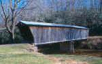
HUMPBACK
BRIDGE 46-03-01, Multiple Kingpost Truss, built in 1857, &
completely restored in 1953, is located West of Covington, off
VA60, in roadside park.
The
GPS location is N37 48.031 W80 02.825.
|
GILES
COUNTY
 |
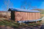
SINKING
CREEK, CLOVER BRIDGE 46-35-01, Queenpost Truss variant, built
in 1916, is located at the Northern edge of Newport, on bypassed
section of VA601.
The
GPS location is N37 18.419 W80 29.859.
|
 |
LINK'S
FARM BRIDGE 46-35-02, Queenpost Truss variant, built in 1912 is
located at the Northwestern edge of Newport, off VA700, maybe
0.1 mile on bypassed section of road, off Route 460.
The
GPS location is N37 18.664 W80 31.014.
|
 |
C. K. REYNOLDS/RED MAPLE FARM BRIDGE 46-35-03, Private, Queenpost
Truss variant, built in 1919, is located NE of Newport, walk 0.3
miles right on farm road, off VA 42. Permission required. It was
blown down by high winds. It will be completely rebuilt by owner,
as authentiic as possible.
The
GPS location is N37 19.152 W80 27.271.
|
PATRICK
COUNTY
 |
BOB
WHITE, LOWER BRIDGE 46-68-01, Queenpost Truss, built in 1920,
is located SE of Woolwine, on bypassed section of VA618. It was
destroyed by floodwaters.
The
GPS location is N36 46.765 W80 14.846.
|
 |
JACKS
CREEK, UPPER BRIDGE 46-68-02, Queenpost Truss, built in 1916,
is located South of Woolwine, on bypassed section of VA615.
The
GPS location is N36 45.857 W80 16.412.
|
PITTSYLVANIA
COUNTY
 |
WARD'S
FARM BRIDGE 46-70-C, Stringer, built in 1987, is located NNW of
Gretna, on the S. side of Paisley Road at 2632 SR756. Ask permission
across the street.
The
GPS location is N37 02.35 W79 23.80. (approximate)
|
ROCKINGHAM
COUNTY
 |
BEIDLER
FARM BRIDGE 46-79-01, Burr variant, built c. 1800, is located
East of Broadway. The bridge is located on private road opposite
VA796 West.
The
GPS location is N38 35.001 W78 42.658.
|
SHENANDOAH
COUNTY
 |
MEEM'S
BOTTOM BRIDGE 46-82-01, Burr Arch Truss, built in 1892, &
completely restored in 1979, is located South of Mount Jackson,
on VA720 (Wissler Road).
The
GPS location is N38 43.25 W78 39.31.
|
|