|
GRAFTON
COUNTY
 |
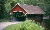
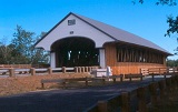
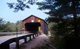
SWIFTWATER
BRIDGE 29-05-02, Paddleford Truss, built in 1849, restored in
1989 & 1999, is located at the Village of Swiftwater, on Valley
Road.
The
GPS location is N44 08.03 W71 57.06.
|
 |
BATH
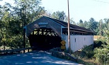
BRIDGE 29-05-03 MULTIPLE, Kingpost Trussw/Arch, built in 1832,
completely restored in 1988, is located in the town of Bath, on
old Woodsville Road.
The
GPS location is N44 10.01 W71 58.01.
|
 |
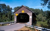
BATH/HAVERHILL,
WOODSVILLE BRIDGE 29-05-04, Town Lattice Truss, built in 1827,
is located at the northern edge of Woodsville, on NH 135.
The
GPS location is N44 09.278 W72 02.173.
|
 |
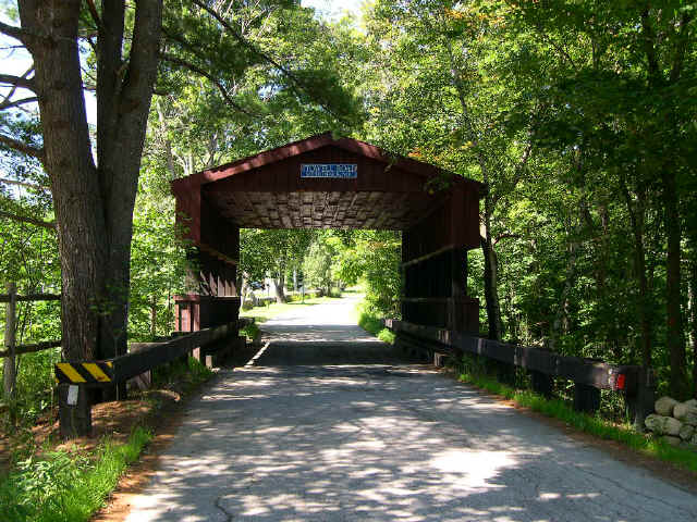
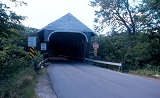
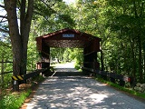
FLUME, FRANCONIA NOTCH BRIDGE 29-05-05, Paddleford Truss, built
in 1866. It is located in Flume Reservation, in Franconia Notch
State Park, off I-93 at exit 33.
The
GPS location is N44 05.958 W71 40.625.
|
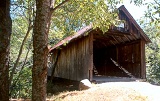 |
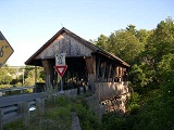
TURKEY
JIM BRIDGE 29-05-07#2, Queenpost Truss, built in 1965, it is located
north of West Campton at Branch Brook Campground, off US 49, at
exit 28 of I-89. It has been rebuilt and placed back on its
abutments on October 13, 2013. Ask at office for permission to
visit.
The
GPS location was N43 51.135 W71 39.554.
|
 |
BUMP
BRIDGE 29-05-08#2, Queenpost Truss, built in 1972, is located
ESE of Campton Hollow on Bumps Intervale Road.
The
GPS location is N43 48.873 W71 37.305.
|
 |
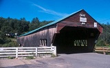
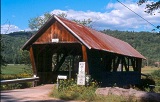
BLAIR
BRIDGE 29-05-09, Long Truss w/Arch, built in 1869, completely
restored in 1983, is located NNE of Plymouth, at the Village of
Blair on Blair Road.
The
GPS location is N43 48.619 & W71 39.944.
|
 |
SMITH
MILLENNIUM BRIDGE 29-05-10#2, Town Lattice Truss. It was originally
built in 1880, arsoned & has been rebuilt by the firm of Stanley
Graton II. It is located WNW of Plymouth, on Smith Bridge Road.
The
GPS location is N43 46.517 W71 44.342.
|
 |
EDGELL,
LYME ORFORD BRIDGE 29-05-11, Town Lattice Truss, built in 1885
is located SSW of Orford, on River Road.
The
GPS location is N43 52.07 W72 09.88.
|
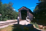 |
CLARK,
PINSLEY RAILROAD BRIDGE 29-05-14, formerly 45-12-16, Howe Truss,
built in Washington County, Vermont in 1904, is located North
of North Woodstock at Clark's Trading Post off US 3, moved there
in 1965.
The
GPS location is N44 03.08 W71 41.25.
|
|
|
JACK O'LANTERN RESORT 29-05-18, Town Lattice Truss. Built in 1986,
it is located South of Woodstock on US 3, in the Jack O' Lantern
Resort.
The
GPS location is N43 56.958 W71 40.616.
|
 |
PACKARD
HILL BRIDGE 29-05-50#2, Town Lattice Truss, built in 1991, by
the Graton Brothers is located at Baker's Crossing, on Riverside
Drive.
The
GPS location is N43 38.322 W72 13.343.
|
|
|
SQUAM RIVER BRIDGE 29-05-112, Town Lattice Truss, built in 1990
by the Graton Bridge Builders. It is located in Ashland, on Squam
Point Lane.
The
GPS location is N43 43.16 W71 37.12.
|
HILLSBOROUGH
COUNTY
 |
COUNTY
BRIDGE 29-06-02#2, Pratt Truss, built in 1937, is located ESE
of Hancock, on Forest Road.
The
GPS location is N42 57.41 W71 56.09.
|
 |
STOWELL
ROAD 29-06-S, Stringer, built in 1990, is located on Stowell Road,
in Merrimack.
The
GPS location is N42 53.773 W71 38.810.
|
|